


The Journal of San Diego History
SAN DIEGO HISTORICAL SOCIETY QUARTERLY
Summer 1971, Volume 17, Number 3
James E Moss, Editor
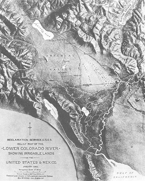
Page iv. The delta of the Colorado River stretches from Indio on the north to the head of the Gulf of California on the south. From Pilot Knob, just above the international line, the crest of the delta extends in a southwesterly direction toward the area marked Volcano Lake; from the crest, it is downhill either northwestward toward the Salton Sink or southward toward the Gulf. Laguna Salada was occasionally filled when the flood waters of the Colorado, confronted by the tremendous Gulf tides, were forced up into this basin pocket. Along the river in the upper right hand corner of the map is the Palo Verde Valley, here labeled as the Blythe Estate.

Page 2. Oliver M. Wozencraft

Page 4. Thomas Henry Blythe

Page 5. Guillermo Andrade

Page 7. Charles Robinson Rockwood

Page 7. George Chaffey

Page 8. The Terminal point of the Southern Pacific line on the border at Calexico, July 7, 1904. The view is looking west (Signal Mountain is lost in the haze), with Mexico to the left and the United States to the right.

Page 9. Early in 1901, Imperial, the mother town of the Valley, was platted, staked, and put on the market by the Imperial Land Company. This is how the town looked from the ice plant water tank in the summer of 1904.

Page 9. The California Development Co. wholesaled water to mutual water companies. This shows the main canal delivering water to Imperial Water Co. No. 1, which served the central portion of the Valley between the New and Alamo rivers. The figure standing on the right bank helps to provide scale.
Illustrations used in this article are provided through the courtesy of the Sherman Foundation, Corona Del Mar, California.


