


The Journal of San Diego History
SAN DIEGO HISTORICAL SOCIETY QUARTERLY
Spring 1999, Volume 45, Number 2
Richard W. Crawford, Editor

The typical image of the California missions is of a chain of highly-centralized institutions, with Indians from a wide area all brought together to work in and around each mission complex. In fact, the missions maintained a vast network of outlying ranchos and asistencias (sub-missions) for farming and grazing. Many had adobe storehouses and homes for the mission mayordomos (foremen); some even had chapels.
Mission San Luis Rey had one of the most extensive chain of outposts, spread out over some 1,000 square miles in what is now San Diego and Riverside counties. These outposts not only provided support for the mission itself, but in the case of San Luis Rey also allowed many of the baptized Indians (neophytes) to remain in their native villages, and serve the mission by working on the ranchos.1
In 1827, the Territorial Legislature ordered each mission to submit an account of their lands and livestock. Father Antonio Peyri, who had served the mission since its founding in 1798, prepared the report for Mission San Luis Rey.2 It is the best single account of the extent of the mission’s influence. His report reads:
The missionary of Mission San Luis Rey, complying with what was ordered by the governor in the pr ocla m ation circulated under date of October 8, gives the following information:
This Mission is situated in a cañada which runs from east to west, named Quechinga by the native
s, at a distance of two leagues [roughly five miles] from the seashore and six leagues from the sierra. It has as neighbors to the south the port and the Mission of San Diego at a distance of about thirteen leagues and a half; to the north Mission San Juan Capistrano at a distance of about twelve leagues and a half. In the east, the Sierra Madre of California is situated at various distances from the seashore, two, three, four, five, six, and seven leagues, the intervening country consisting of cañadas and hills.
As in the case of the valley in which the Mission is situated, there is no running water nor any spring by means of which a harvest could be secured; therefore, the order to found the Mission caused some difficulties in 1798. It was feared that for want of running water no security could be had of maintaining with the crops a community of native gentiles, who might be attracted to the bosom of our Religion. However, confiding in Divine Providence, we established the Mission in a short time on a mesa situated near a marsh, the water of which by hauling earth we succeeded little by little in forcing up so that it could be reached. By means of two dams the water was then collected so that it sufficed for the assembled Indians and for irrigating a garden. This is the only water on which we can depend; for, although there is an arroyo which runs down from the Sierra Madre [the San Luis Rey River], it has abundant water only in the rainy season, from the month of October or November to May or June of the next year, when it is again lost in the sand, so that, the arroyo being then dry, we can not count on it for any seed time.
To the east at a distance of three leagues the Mission has a locality named San Juan for the cattle;3 and in the same direction, at a distance of sixteen leagues, there is another district reserved for the sheep, which is famed for its warm springs. There pasture also the flocks of Mission San Diego.4
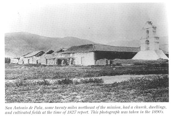
At a distance of seven leagues, toward the northeast, at the entry of the Sierra Madre, the Mission has a station called San Antonio de Pala, with a church, dwellings, and granaries and with a few fields where wheat, corn, beans, garbanzos, and other leguminous plants are grown. There are also a vineyard and an orchard of various fruits and of olives, for which there is sufficient irrigation, the water being from the stream which runs to the vicinity of this Mission.5
To the north, at a distance of one league and a half, the Mission has a place with a house and garden, and near the beginnings of the sierra a vineyard. This site, lying in a cañada, is called Santa Margarita. The land is cultivated and wheat, corn, beans, and barley are raised. The fields are irrigated by means of the water from the sierra, which, though not plentiful, assures good crops.6
In the same direction, to the north, at a distance of three leagues, the Mission has the Rancho of San Pedro, known as Las Flores. The place has a house, granaries, and a chapel, which buildings form a square or large patio. Holy Mass is offered up in the chapel. In the patio, by means of water taken out of a pool near the sea, corn is raised. In the plain, wheat and barley are raised in season. About one league from the rancho are the pastures for the cattle. The locality is called Las Pulgas.7
In the direction of the northeast, in the sierra, at a distance of twelve leagues, the Mission has the Rancho of San Jacinto with a house of adobes for the mayordomos. Here pasture the cattle.8
Between the said ranchos, sites, and stations, there are no mountains whatever; but the valleys and mesas are covered with thickets and underbrush, which are good only for firewood. In the clearings and foothills, cattle and sheep have their pasture.9
Two leagues east of the station of San Antonio de Pala, and nine leagues from the Mission, in the sierra [Palomar Mountain], there is a forest of pines and firs (pinabete) and larches (alerce), where the timber was cut for the buildings of the Mission and of the other stations….
The Mission Indians at present own 22,610 head of cattle, 27,412 sheep, 1,120 goats, 280 pigs, 1,501 horses of all kinds, and 235 mules. All these animals are distributed over the ranchos, sites, and stations described. The reason for having them so scattered is the lack of water and pastures, which are difficulties encountered all along this coast region. Necessity compels searching for both in the cañadas which the Sierra Madre offers for the planting of grain as well as for pastures for the live stock, so that we may be able to maintain in community the native converts, as also the gentiles who come to have themselves instructed, preparatory to becoming Christians; and also to supply the troops of the garrison of San Diego with corn, beans, wheat, manteca, soap, blankets, mantles, and shoes.
Mission San Luis Rey
December 22, 1827.
Fr. Antonio Peyri


With the secularization of the California Missions in the early 1830s, the Franciscan padres were forced to turn over control of the mission holdings to government-appointed administrators. Mission Luis Rey was secularized in 1835, and the government began to grant its outlying ranchos to private rancheros — often the administrators or their families. Mission San Luis Rey fell into disrepair, but was restored beginning in the 1890s and today is both an active parish and a busy tourist stop. The asistencia at Pala has also survived, but the rest of the ranchos of the Mission San Luis Rey are now all but forgotten.
1. “In contrast to baptismal patterns documented at missions in much of the rest of California,” a recent study of San Luis Rey’s records notes, “Mission San Luis Rey appears to have coexisted with nearby native communities for a much longer period of time without fully absorbing their populations…. This may be the result of a conscious decision by the head missionary at Mission San Luis Rey, Fr. Antonio Peyri, to permit a certain number of baptized Luisenos to remain living apart from the mission with their unconverted relatives at their rancherias [villages]. The native communities in this way gradually became converted into mission ranchos at Santa Margarita, Las Flores, Las Pulgas, San Jacinto, Temecula, Pala, etc.” John Johnson, Dinah Crawford, Stephen O’Neil, “The Ethnohistoric Basis for Cultural Affiliation in the Camp Pendleton Marine Base Area: Contributions to Luiseno and Juaneno Ethnohistory Based on Mission Register Research,” (Unpublished report, 1998. Courtesy Dr. John Johnson).
2. Translated and quoted in full in Father Zephyrin Engelhardt, San Luis Rey Mission (San Francisco: The James H. Barry Company, 1921), pp 50-53.
3. This is perhaps a forgotten missionary name for the Guajome area in the rolling hills north of the modern city of Vista and east of the San Marcos Mountains. Notice that San Luis Rey’s ranchos vary between native names (Temecula, Pala), and Spanish names (Las Flores, San Jacinto). The Rancho San Juan is listed in the final inventory of Mission San Luis Rey, prepared by the padres in 1835, though with a low value which suggests there were no mission buildings there — perhaps because it was so close to the mission proper. Engelhardt, San Luis Rey, p. 98.
It was perhaps after 1827 that the mission began to make active use of the San Marcos area, which is listed separately from the Rancho San Juan in the closing inventory of the mission in 1835. Ibid. Again, its low value as shown on the inventory suggests the mission never built an adobe there.
4. Though known as the Valle de San Jose since 1795, the valley is most commonly called the Warner Ranch, after J.J. Warner, who obtained a Mexican land grant there in 1844. During mission times, San Luis Rey’s rancho in the north end of the valley was usually called Agua Caliente, while San Diego’s rancho was known as the Valle de San Jose. Sometime around 1830, San Luis Rey built a storehouse just below Warner Hot Springs on the little hill where the chapel of Saint Francis now stands. See, Joseph Hill, The History of Warner’s Ranch and its Environs, (Los Angeles: Privately Printed, 1927). The present chapel, often identified as a mission-era building, was in fact built in the mid-1890s. See, R. Bruce Harley, “Indian Mission Chapels of Riverside County”, (Diocesan Heritage Series, Diocese of San Bernardino Archives, n.d. [ca 1988]). Visiting priests still hold regular services there.
5. A granary was built at Pala in 1810, and the asistencia officially founded in 1816. The chapel was complete by 1818 and is the only original building extant (much of the present quadrangle was built in the 1950s). Even the famous campanile was rebuilt after it collapsed during the floods of 1916. See, Fr. J.M. Carrillo, The Story of Mission San Antonio de Pala (Balboa Island: Paisano Press, 1959). In the 1820s, it was proposed to elevate Pala to full mission status, as part of a second chain of inland missions, but the plan never came to fruition. See, George William Beattie, California’s Unbuilt Missions, (N.P.: The Author, 1930.) The chapel is still an active parish today under the charge of the Verona Fathers.
6. The adobe house, said to have been built around 1806 for the mission’s mayordomo, was later enlarged to become the headquarters for the Rancho Santa Margarita y Las Flores. Today it serves as the Base Commander’s residence for Camp Pendleton. Don C. Meadows, “From Missionaries to Marines, Rancho Santa Margarita y Las Flores,” The Westerners Brand Book #13 (Los Angeles: Los Angeles Corral of the Westerners, 1969).
7. San Luis Rey was keeping sheep at Las Flores as early as 1810. The chapel and adjoining buildings there were built in 1823. Engelhardt, San Luis Rey, pp 22, 36. The buildings formed three sides of a square, 142 by 153 feet, all roofed with tile. A portion of the south wing had a second story, and the campanile was used as a navigational landmark by early sailing ships. Meadows, “From Missionaries to Marines”, 1969. The foundations and one bit of wall, are still visible on a rise just south of Las Pulgas Road, on Camp Pendleton. Since 1973, the area around the ruins (including the 1868 Marcos Forster Adobe) has been leased to the Orange County Council of the Boy Scouts of America, who operate it as a weekend camp known as Rancho Las Flores.
Las Pulgas Canyon still bears that name. The mission rancho north of Las Flores was also sometimes known as San Onofre, and adjoined Mission San Juan Capistrano’s Rancho San Mateo to the north. Father Zephyrin Engelhardt, San Juan Capistrano Mission (Los Angeles: Standard Printing Company, 1922), p. 88.
8. The adobe was located on a small hill just north of the modern intersection of the Ramona Expressway and Warren Road. It must have been built sometime after September, 1821, when Father Jose Sanchez visited the rancho and reported only an enramada (ramada) there. Engelhardt, San Luis Rey, p. 45. Later known as the Casa Loma, the old mission adobe was rebuilt several times over the years, and stood until it was destroyed by fire in 1969. See, John W. Robinson, “Rancho San Jacinto Viejo and the Estudillo Family,” in Rancho Days in Southern California [Brand Book #20], (Los Angeles: Los Angeles Corral of the Westerners, 1997), pp 143-161.
9. Missing from this report is the mission rancho at Temecula, which seems to have been used by the mission as early as 1821. Engelhardt, San Luis Rey, p. 45. It is also mentioned in mission reports for 1828 and 1830. A house for the mission’s mayordomo was later built on a little mesa on the south side of the mouth of Temecula Canyon. A long granary was located a short ways southeast, near where Rainbow Canyon Road now enters the valley. B.E. McCown, Temeku: A Page from the History of the Luiseno Indians, (Los Angeles: Papers of the Archaeological Survey Association of Southern California, Report #3, 1955).
Phil Brigandi has been researching and writing local history since 1975. A native of Orange, California, he has written several books on the history of his hometown. He has worked as a historical consultant for the Anza-Borrego Desert State Park, and has been active with the Anza-Borrego Desert Natural History Association for many years. Mr. Brigandi currently lives in Hemet, California, where he serves as Pageant Historian for the Ramona Pageant. His most recent book is Temecula, At the Cross Roads of History.


